世界の国
1+
Downloads

Everyone
info
About this app
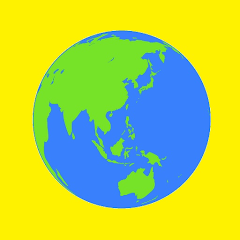
Displays detailed information, national flags, and maps of 198 countries around the world. Maps can be registered in the database and can usually be displayed in four types: satellite, satellite +, and terrain.
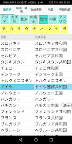
1. 1. Country selection
Touch the region or Akasatana, and then touch the country you want to display.
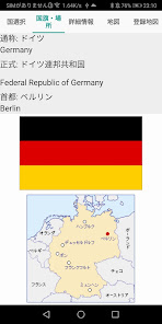
2. National flag / location
The official country name, capital, national flag, and country location of the touched country are displayed.
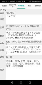
3. 3. Detailed information
The capital, language, area, ethnicity, population, religion, currency, and industry of the touched country are displayed.
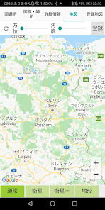
4. map
The map of the touched country is displayed. The map is enlarged with + and reduced with-. The map can usually display four types: satellite, satellite + (adding a place name to the satellite), and terrain. Touch Register to register in the database. Move the Orientation and Angle track bar to change the Orientation and Angle on the map.
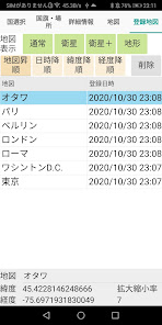
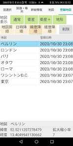
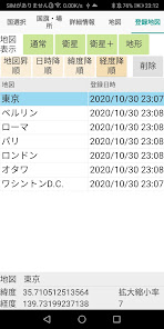
5. Registration map
It is a database of registered maps. You can sort the map in ascending order, date and time descending order (from new registration), latitude descending order (north to south), and longitude descending order (east to west). Normally, if you touch satellite, satellite +, or terrain on the map display toolbar, the map registered in the database will be displayed at the scaling ratio at the time of registration.
1. 1. Country selection
Touch the region or Akasatana, and then touch the country you want to display.
2. National flag / location
The official country name, capital, national flag, and country location of the touched country are displayed.
3. 3. Detailed information
The capital, language, area, ethnicity, population, religion, currency, and industry of the touched country are displayed.
4. map
The map of the touched country is displayed. The map is enlarged with + and reduced with-. The map can usually display four types: satellite, satellite + (adding a place name to the satellite), and terrain. Touch Register to register in the database. Move the Orientation and Angle track bar to change the Orientation and Angle on the map.
5. Registration map
It is a database of registered maps. You can sort the map in ascending order, date and time descending order (from new registration), latitude descending order (north to south), and longitude descending order (east to west). Normally, if you touch satellite, satellite +, or terrain on the map display toolbar, the map registered in the database will be displayed at the scaling ratio at the time of registration.
Updated on
Safety starts with understanding how developers collect and share your data. Data privacy and security practices may vary based on your use, region, and age. The developer provided this information and may update it over time.

No data shared with third parties
Learn more about how developers declare sharing

No data collected
Learn more about how developers declare collection
What's new
2020年10月 新規リリース


