
河川地図
Contains ads
1K+
Downloads

Everyone
info
About this app
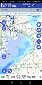
Displays rainfall, river camera, water level gauge, weather forecast, map, map, address. We use data from the Ministry of Land, Infrastructure, Transport and Tourism, the Japan Meteorological Agency, and the Geospatial Information Authority of Japan.
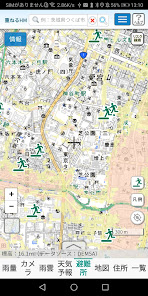
1.[Rainfall] displays the rainfall information observed by the radar rain gauge (XRAIN). We use data from the Ministry of Land, Infrastructure, Transport and Tourism.
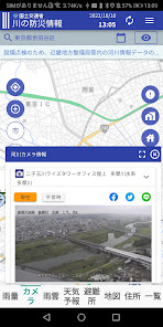
2. [Camera] is a live camera installed in the river, and you can see the current state of the river. We use data from the Ministry of Land, Infrastructure, Transport and Tourism.
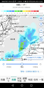
3.[Rain clouds] is a rain cloud radar near your current location.
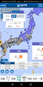
4. [Weather Forecast] displays the weather forecast for today and up to 6 days later. We use data from the Japan Meteorological Agency.
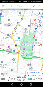
5.[Refuge] displays the estimated flood inundation area and the designated emergency evacuation site (flood). We use data from the Geospatial Information Authority of Japan.
6. [Map] is a normal map.
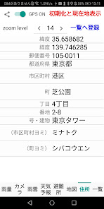
7. [Address] displays the latitude, longitude, postal code, prefecture, city, town, chome, house number, number/building, city reading, and town reading of the current location.
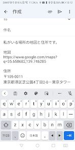
By touching the share button (<), you can send the URL of the map of your current location and the address by e-mail, so you can let your family and friends know where you are. Please use it as an emergency contact.
When the GPS switch is turned on (green), the location information sensor will move and the latitude, longitude and address of your current location will be displayed.
When you touch [Initialize and display current location], the rainfall, camera, rain clouds, shelter, map, and zoom level settings are initialized and the current location is displayed.
When you touch [Register to list], the displayed address data will be registered in the database. You can scale the map by changing the zoom level. The minimum is 1, the maximum is 20, and the initial value is 16.
8. [List] is a list of locations registered in the database. Registered locations can be sorted in ascending order of date/time, ascending address, descending latitude, descending longitude, and can be displayed at the zoom level at the time of registration. Map zoom levels range from 1 to 20, others may have smaller ranges. Touch ALL to display all registered data.
1.[Rainfall] displays the rainfall information observed by the radar rain gauge (XRAIN). We use data from the Ministry of Land, Infrastructure, Transport and Tourism.
2. [Camera] is a live camera installed in the river, and you can see the current state of the river. We use data from the Ministry of Land, Infrastructure, Transport and Tourism.
3.[Rain clouds] is a rain cloud radar near your current location.
4. [Weather Forecast] displays the weather forecast for today and up to 6 days later. We use data from the Japan Meteorological Agency.
5.[Refuge] displays the estimated flood inundation area and the designated emergency evacuation site (flood). We use data from the Geospatial Information Authority of Japan.
6. [Map] is a normal map.
7. [Address] displays the latitude, longitude, postal code, prefecture, city, town, chome, house number, number/building, city reading, and town reading of the current location.
By touching the share button (<), you can send the URL of the map of your current location and the address by e-mail, so you can let your family and friends know where you are. Please use it as an emergency contact.
When the GPS switch is turned on (green), the location information sensor will move and the latitude, longitude and address of your current location will be displayed.
When you touch [Initialize and display current location], the rainfall, camera, rain clouds, shelter, map, and zoom level settings are initialized and the current location is displayed.
When you touch [Register to list], the displayed address data will be registered in the database. You can scale the map by changing the zoom level. The minimum is 1, the maximum is 20, and the initial value is 16.
8. [List] is a list of locations registered in the database. Registered locations can be sorted in ascending order of date/time, ascending address, descending latitude, descending longitude, and can be displayed at the zoom level at the time of registration. Map zoom levels range from 1 to 20, others may have smaller ranges. Touch ALL to display all registered data.
Updated on
Safety starts with understanding how developers collect and share your data. Data privacy and security practices may vary based on your use, region, and age. The developer provided this information and may update it over time.

No data shared with third parties
Learn more about how developers declare sharing

No data collected
Learn more about how developers declare collection
What's new
微修正


