
地形地図
Contains ads
100+
Downloads

Everyone
info
About this app
Displays the altitude of the current location, altitude by color, slope amount, shading relief, aerial photo, normal map, and address. Since you can grasp the terrain of your current location, it is useful for terrain interpretation and mountain climbing.
1. [Elevation] is an elevation map. High and low are represented by elevation lines, and you can see the altitude.
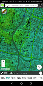
2.[Color] is an elevation map that is color-coded according to altitude.
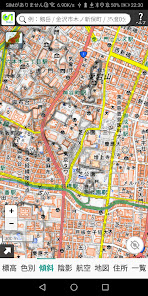
3.[Inclination] is a slope map that calculates the amount of inclination of the ground surface and expresses its magnitude in black and white shades. White means gentle slope, black means steep slope. It is useful for interpreting landforms such as plateaus, terraces, mountains, volcanic landforms, landslides, and faults.
4. [Shadow] is a shaded relief map created by illuminating the ground surface from the northwest direction so that the northwest side of the uneven ground surface is white and the southeast side is black. It is useful for identifying ridge lines and valley lines, and for interpreting faults.
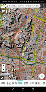
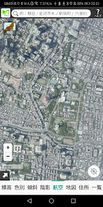
5. [Aerial] is an aerial photograph.
Source of the above Geospatial Information Authority of Japan https://maps.gsi.go.jp/development/ichiran.html
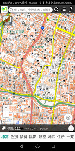
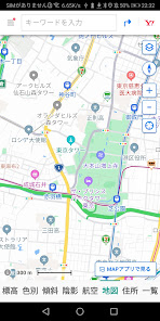
6. [Map] is a normal map.
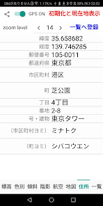
7. [Address] displays the latitude, longitude, postal code, prefecture, city, town, chome, house number, number/building, city reading, and town reading of the current location.
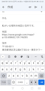
By touching the share button (<), you can send the URL of the map of your current location and the address by e-mail, so you can let your family and friends know where you are. Please use it as an emergency contact.
When the GPS switch is turned on (green), the location information sensor will move and the latitude, longitude and address of your current location will be displayed.
When you touch [Initialize and display current location], the altitude, color, slope, shading, aviation, map, and zoom level settings are initialized and the current location is displayed.
When you touch [Register to list], the displayed address data will be registered in the database. You can scale the map by changing the zoom level. The minimum is 1, the maximum is 21, and the initial value is 16.
8. [List] is a list of locations registered in the database. Registered locations can be sorted in ascending order of date/time, ascending address, descending latitude, descending longitude, and can be displayed at the zoom level at the time of registration. Map zoom levels range from 1 to 21, others may have smaller ranges. Touch ALL to display all registered data.
1. [Elevation] is an elevation map. High and low are represented by elevation lines, and you can see the altitude.
2.[Color] is an elevation map that is color-coded according to altitude.
3.[Inclination] is a slope map that calculates the amount of inclination of the ground surface and expresses its magnitude in black and white shades. White means gentle slope, black means steep slope. It is useful for interpreting landforms such as plateaus, terraces, mountains, volcanic landforms, landslides, and faults.
4. [Shadow] is a shaded relief map created by illuminating the ground surface from the northwest direction so that the northwest side of the uneven ground surface is white and the southeast side is black. It is useful for identifying ridge lines and valley lines, and for interpreting faults.
5. [Aerial] is an aerial photograph.
Source of the above Geospatial Information Authority of Japan https://maps.gsi.go.jp/development/ichiran.html
6. [Map] is a normal map.
7. [Address] displays the latitude, longitude, postal code, prefecture, city, town, chome, house number, number/building, city reading, and town reading of the current location.
By touching the share button (<), you can send the URL of the map of your current location and the address by e-mail, so you can let your family and friends know where you are. Please use it as an emergency contact.
When the GPS switch is turned on (green), the location information sensor will move and the latitude, longitude and address of your current location will be displayed.
When you touch [Initialize and display current location], the altitude, color, slope, shading, aviation, map, and zoom level settings are initialized and the current location is displayed.
When you touch [Register to list], the displayed address data will be registered in the database. You can scale the map by changing the zoom level. The minimum is 1, the maximum is 21, and the initial value is 16.
8. [List] is a list of locations registered in the database. Registered locations can be sorted in ascending order of date/time, ascending address, descending latitude, descending longitude, and can be displayed at the zoom level at the time of registration. Map zoom levels range from 1 to 21, others may have smaller ranges. Touch ALL to display all registered data.
Updated on
Safety starts with understanding how developers collect and share your data. Data privacy and security practices may vary based on your use, region, and age. The developer provided this information and may update it over time.

No data shared with third parties
Learn more about how developers declare sharing

No data collected
Learn more about how developers declare collection
What's new
・標高図、航空写真を追加しました。
・現在地をデータベースに登録できるようになりました。
・現在地をデータベースに登録できるようになりました。


