
防災地図
Contains ads
500+
Downloads

Everyone
info
About this app
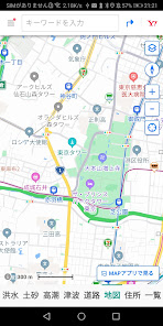
Displays floods, landslides, storm surges, tsunamis, road disaster information hazard maps (disaster maps), designated emergency evacuation sites, normal maps, and addresses for the current location.
You can find the designated emergency evacuation site near your current location, which is useful for evacuation in the event of a disaster.
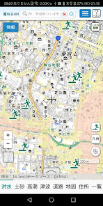
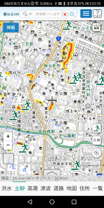
1. [Flood] displays flood hazard maps and designated emergency evacuation sites.
2.[Sediment] displays the hazard map of landslide disasters and designated emergency evacuation sites.
3. [Storm Surge] displays storm surge hazard maps and designated emergency evacuation sites.
4.[Tsunami] displays tsunami hazard maps and designated emergency evacuation sites.
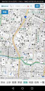
5.[Road] displays hazard maps and designated emergency evacuation sites for road disaster prevention information.
Source of the above Geospatial Information Authority of Japan https://maps.gsi.go.jp/development/ichiran.html
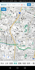
6. [Map] is a normal map.
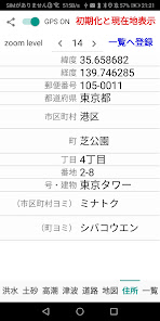
7. [Address] displays the latitude, longitude, postal code, prefecture, city, town, chome, house number, number/building, city reading, and town reading of the current location.
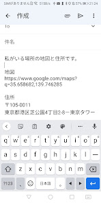
By touching the share button (<), you can send the URL of the map of your current location and the address by e-mail, so you can let your family and friends know where you are. Please use it for emergency communication in the event of a disaster.
When the GPS switch is turned on (green), the location information sensor will move and the latitude, longitude and address of your current location will be displayed.
When you touch [Initialize and display current location], the flood, sediment, storm surge, tsunami, road, map, and zoom level settings are initialized and the current location is displayed.
When you touch [Register to list], the displayed address data will be registered in the database. You can scale the map by changing the zoom level. The minimum is 1, the maximum is 21, and the initial value is 16.
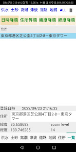
8. [List] is a list of locations registered in the database. Registered locations can be sorted in ascending order of date/time, ascending address, descending latitude, descending longitude, and can be displayed at the zoom level at the time of registration. Map zoom levels range from 1 to 21, others may have smaller ranges. Touch ALL to display all registered data.
You can find the designated emergency evacuation site near your current location, which is useful for evacuation in the event of a disaster.
1. [Flood] displays flood hazard maps and designated emergency evacuation sites.
2.[Sediment] displays the hazard map of landslide disasters and designated emergency evacuation sites.
3. [Storm Surge] displays storm surge hazard maps and designated emergency evacuation sites.
4.[Tsunami] displays tsunami hazard maps and designated emergency evacuation sites.
5.[Road] displays hazard maps and designated emergency evacuation sites for road disaster prevention information.
Source of the above Geospatial Information Authority of Japan https://maps.gsi.go.jp/development/ichiran.html
6. [Map] is a normal map.
7. [Address] displays the latitude, longitude, postal code, prefecture, city, town, chome, house number, number/building, city reading, and town reading of the current location.
By touching the share button (<), you can send the URL of the map of your current location and the address by e-mail, so you can let your family and friends know where you are. Please use it for emergency communication in the event of a disaster.
When the GPS switch is turned on (green), the location information sensor will move and the latitude, longitude and address of your current location will be displayed.
When you touch [Initialize and display current location], the flood, sediment, storm surge, tsunami, road, map, and zoom level settings are initialized and the current location is displayed.
When you touch [Register to list], the displayed address data will be registered in the database. You can scale the map by changing the zoom level. The minimum is 1, the maximum is 21, and the initial value is 16.
8. [List] is a list of locations registered in the database. Registered locations can be sorted in ascending order of date/time, ascending address, descending latitude, descending longitude, and can be displayed at the zoom level at the time of registration. Map zoom levels range from 1 to 21, others may have smaller ranges. Touch ALL to display all registered data.
Updated on
Safety starts with understanding how developers collect and share your data. Data privacy and security practices may vary based on your use, region, and age. The developer provided this information and may update it over time.

No data shared with third parties
Learn more about how developers declare sharing

No data collected
Learn more about how developers declare collection
What's new
住所をデータベースに登録できるようになりました。


