
交通地図
Contains ads
100+
Downloads

Everyone
info

About this app
It shows traffic jams, rain clouds, maps and addresses for your current location, as well as highways and weather forecasts. You can grasp the traffic and weather of your current location, so it is useful when you go out.
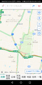
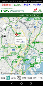
1. [Congestion] is the traffic congestion situation of the road near the current location. Congested areas are shown in red.
2. [Expressway] is the congestion situation of the expressway. You can also search for service areas, highway tolls, and routes.
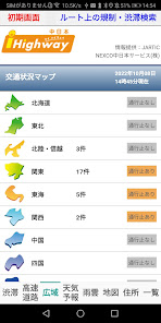
3. [Wide area] is a map of traffic conditions by district from Hokkaido to Kyushu. You can also search for restrictions and congestion on the route.
4. [Weather forecast] is the nationwide weather forecast. The weather forecast for today and one week from now is displayed.
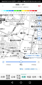
5.[Rain clouds] is a rain cloud radar near your current location.
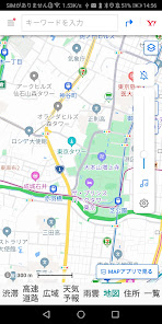
6. [Map] is a normal map.
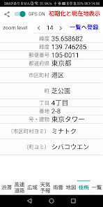
7. [Address] displays the latitude, longitude, postal code, prefecture, city, town, chome, house number, number/building, city reading, and town reading of the current location.
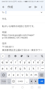
By touching the share button (<), you can send the URL of the map of your current location and the address by e-mail, so you can let your family and friends know where you are. Please use it as an emergency contact.
When the GPS switch is turned on (green), the location information sensor will move and the latitude, longitude and address of your current location will be displayed.
When you touch [Initialize and display current location], the altitude, color, slope, shading, aviation, map, and zoom level settings are initialized and the current location is displayed.
When you touch [Register to list], the displayed address data will be registered in the database. You can scale the map by changing the zoom level. The minimum is 1, the maximum is 21, and the initial value is 16.
8. [List] is a list of locations registered in the database. Registered locations can be sorted in ascending order of date/time, ascending address, descending latitude, descending longitude, and can be displayed at the zoom level at the time of registration. Map zoom levels range from 1 to 21, others may have smaller ranges. Touch ALL to display all registered data.
1. [Congestion] is the traffic congestion situation of the road near the current location. Congested areas are shown in red.
2. [Expressway] is the congestion situation of the expressway. You can also search for service areas, highway tolls, and routes.
3. [Wide area] is a map of traffic conditions by district from Hokkaido to Kyushu. You can also search for restrictions and congestion on the route.
4. [Weather forecast] is the nationwide weather forecast. The weather forecast for today and one week from now is displayed.
5.[Rain clouds] is a rain cloud radar near your current location.
6. [Map] is a normal map.
7. [Address] displays the latitude, longitude, postal code, prefecture, city, town, chome, house number, number/building, city reading, and town reading of the current location.
By touching the share button (<), you can send the URL of the map of your current location and the address by e-mail, so you can let your family and friends know where you are. Please use it as an emergency contact.
When the GPS switch is turned on (green), the location information sensor will move and the latitude, longitude and address of your current location will be displayed.
When you touch [Initialize and display current location], the altitude, color, slope, shading, aviation, map, and zoom level settings are initialized and the current location is displayed.
When you touch [Register to list], the displayed address data will be registered in the database. You can scale the map by changing the zoom level. The minimum is 1, the maximum is 21, and the initial value is 16.
8. [List] is a list of locations registered in the database. Registered locations can be sorted in ascending order of date/time, ascending address, descending latitude, descending longitude, and can be displayed at the zoom level at the time of registration. Map zoom levels range from 1 to 21, others may have smaller ranges. Touch ALL to display all registered data.
Updated on
Safety starts with understanding how developers collect and share your data. Data privacy and security practices may vary based on your use, region, and age. The developer provided this information and may update it over time.

No data shared with third parties
Learn more about how developers declare sharing

No data collected
Learn more about how developers declare collection
What's new
・高速道路、天気予報を追加しました。
・現在地をデータベースに登録できるようになりました。
・現在地をデータベースに登録できるようになりました。


