BLM Public Lands Map Guide USA
3.3star
29 reviews
5K+
Downloads

Everyone
info


About this app
The United States of America is a vast land full of lush forests, stunning deserts, indescribable landscapes, and fascinating history. You may already know some of the iconic landmarks and wildernesses that the US has to offer, but did you know that there are millions of acres of public Bureau of Land Management property in the Western US? This app is your guide to discovering the unspeakable beauty and recreational potential that is contained within these fabled domains!
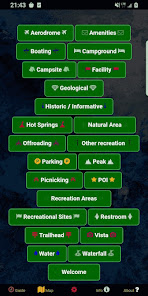
Whether you are a seasoned forest wanderer or are just wanting to learn a little more about the amazing places surrounding your home turf, this app is for you! The data is up to date as of Summer of 2024 and contains over 52,000 recreational points and other features on BLM land. These points are symbolized with several color-coded icons that differentiate between the . Categories include Access Points, Boating, Campgrounds, POIs, Vistas, Bathrooms, Parking Lots, Recreational Areas, and much more! The app even distinguishes property boundaries and includes some hiking trails and roads.
We listened to your feedback and have implemented a number of improvements and features. New in the latest update is a custom My Points tool that allows you to create your own points with unique colors and icons, and even export these points. What other things would you like to see in a future update?
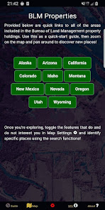
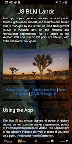
Once using the app, there are five screens. The Guide screen will provide data legends as well as helpful tips for optimizing your navigational experience. On the Info screen, you will find a number of spatial links to the different BLM properties. This is a great way to quickly locate specific places and discover new places to explore! The About screen provides links to all of the open-source resources used in the app and gives a little information about the developer GeoPOI. The Map Settings screen is where you can change between one of four different basemaps, download offline imagery, turn on geolocation, and toggle specific point categories. Finally, the Map screen is where it all comes together!
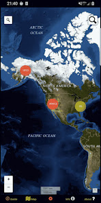
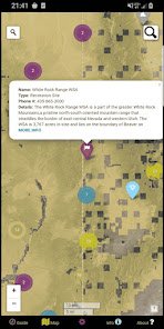
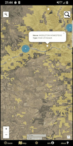
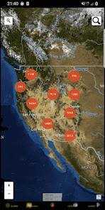
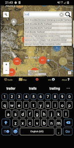
On the Map screen, there are a series of circle clusters at distant zooms that indicate how many points are within a given cluster. As you tap the clusters to zoom in, individual points and icons become visible, along with trails, roads, and boundaries. These features can be clicked on to reveal the name, location, and other useful information. The map screen also has two search tools - the left one can be used to look up addresses and towns, while the right one will allow you to query the names of the features in the database.
There is such a wealth of beauty out there waiting to be discovered. Never before has it been this easy to navigate our public lands as you travel, no matter where in the United States you are or what kinds of places you are interested in visiting. It's time to experience the rich natural and cultural tapestry of our nation and pay homage to the places that make our country the great land that it is. Come navigate the US BLM lands with GeoPOI today!
NOTE: GeoPOI LLC is not associated with the Bureau of Land Management or the US Government. We include official data from these sources in our apps for your convenience, but are in independent entity.
Point data derived from:
https://catalog.data.gov/dataset/blm-natl-recreation-site-points
Facility information is derived from:
https://gis.blm.gov/arcgis/rest/services/recreation/
Boundary data is from:
https://www.usgs.gov/programs/gap-analysis-project/science/pad-us-data-download
Whether you are a seasoned forest wanderer or are just wanting to learn a little more about the amazing places surrounding your home turf, this app is for you! The data is up to date as of Summer of 2024 and contains over 52,000 recreational points and other features on BLM land. These points are symbolized with several color-coded icons that differentiate between the . Categories include Access Points, Boating, Campgrounds, POIs, Vistas, Bathrooms, Parking Lots, Recreational Areas, and much more! The app even distinguishes property boundaries and includes some hiking trails and roads.
We listened to your feedback and have implemented a number of improvements and features. New in the latest update is a custom My Points tool that allows you to create your own points with unique colors and icons, and even export these points. What other things would you like to see in a future update?
Once using the app, there are five screens. The Guide screen will provide data legends as well as helpful tips for optimizing your navigational experience. On the Info screen, you will find a number of spatial links to the different BLM properties. This is a great way to quickly locate specific places and discover new places to explore! The About screen provides links to all of the open-source resources used in the app and gives a little information about the developer GeoPOI. The Map Settings screen is where you can change between one of four different basemaps, download offline imagery, turn on geolocation, and toggle specific point categories. Finally, the Map screen is where it all comes together!
On the Map screen, there are a series of circle clusters at distant zooms that indicate how many points are within a given cluster. As you tap the clusters to zoom in, individual points and icons become visible, along with trails, roads, and boundaries. These features can be clicked on to reveal the name, location, and other useful information. The map screen also has two search tools - the left one can be used to look up addresses and towns, while the right one will allow you to query the names of the features in the database.
There is such a wealth of beauty out there waiting to be discovered. Never before has it been this easy to navigate our public lands as you travel, no matter where in the United States you are or what kinds of places you are interested in visiting. It's time to experience the rich natural and cultural tapestry of our nation and pay homage to the places that make our country the great land that it is. Come navigate the US BLM lands with GeoPOI today!
NOTE: GeoPOI LLC is not associated with the Bureau of Land Management or the US Government. We include official data from these sources in our apps for your convenience, but are in independent entity.
Point data derived from:
https://catalog.data.gov/dataset/blm-natl-recreation-site-points
Facility information is derived from:
https://gis.blm.gov/arcgis/rest/services/recreation/
Boundary data is from:
https://www.usgs.gov/programs/gap-analysis-project/science/pad-us-data-download
Updated on
Safety starts with understanding how developers collect and share your data. Data privacy and security practices may vary based on your use, region, and age. The developer provided this information and may update it over time.

No data shared with third parties
Learn more about how developers declare sharing

No data collected
Learn more about how developers declare collection
Ratings and reviews
3.3
29 reviews

Hart Art (Hart)
- Flag inappropriate
April 7, 2024
Fantastic app with great features and tools. Best app I've found to show BLM and USFS Lands along with your location since the Freeroam app quit being offered. Very up to date. Supports your own points along with points of recreation sites, trailheads, camping, offroading, parking, water, restrooms . . . and many more. Has various overlays and map types, geolocation and direct links to specific BLM areas. Thank you for this awesome app !
6 people found this review helpful

Zero Dean
- Flag inappropriate
May 20, 2023
Definitely worth the purchase! For whatever reason, the map layers weren't working correctly when I initially installed this app. I got a refund and wrote to the developer. They sent a screenshot of what it should look like. I tried reinstalling again today and all layers show up correctly. I'm glad I gave this a second chance and appreciate a developer who cares about their work (and customers). Thank you.
27 people found this review helpful

Love Jah
- Flag inappropriate
- Show review history
December 20, 2023
would be great if you had a sliding bar that could change the shadow on the hillshade i have seen this on other maps that way you can see whats in the highlighted areas! your map is fixed, as well, it would be great to be able to pinch zoom spin 360 degrees the map so as to orientate easily with other maps possibly add 3D features to show terain/ slope/ hillshade in 3D maybe real time layers and maybe private property boundries? please consider at least the hillshade slider to adjust shadows!!
3 people found this review helpful
GeoPOI LLC
December 22, 2023
Thank you for your support and feedback! You propose a lot of really good ideas and some of them may eventually be implemented into this app. However, we're a very small development team with other jobs, so it may be some time before these updates can be integrated. We appreciate your review and will try to implement your ideas soon! Thanks again.
What's new
Everything you need to offline-navigate the BLM Lands of the western USA! Now with many new features and updates: Several UI improvements, bug fixes, new base layers and overlays added, custom point adding and route tracking, and so much more!


