
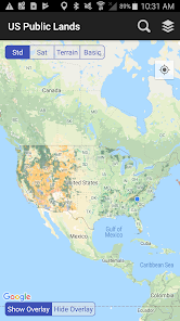
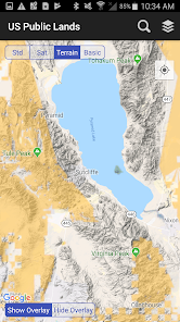
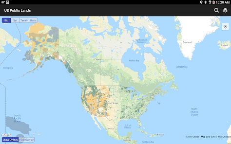
US Public Lands
3.6star
110 reviews
10K+
Downloads

Everyone
info


About this app
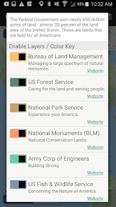
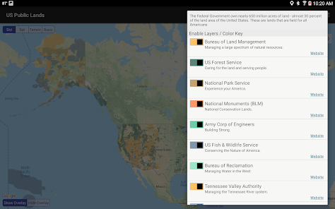
The US Federal Government* owns nearly 650 million acres of land - almost 30 percent of the land area of the United States.
These are lands that are held for all Americans.
Up until now, there has been no quick & easy way to retrieve the boundaries of these properties without carrying physical maps, books, or slowly digging deep online.
Included in this app are on device (fully works offline), individually selectable & beautifully colored layers for most of the properties administered by the federal government:
- Bureau of Land Management (BLM)
- US Forest Service (FS)
- National Park Service (NPS)
- Army Corp of Engineers (ACOE)
- US Fish & Wildlife Service
- Bureau of Reclamation
- Tennessee Valley Authority
- Department of Defense (military bases & installations)
- Other (National Laboratories, Test Sites, etc...)
Key Benefits & Features
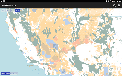
- Know which US agency owns and operates the land you're on or are heading to. Use the "Layers" icon to select which agencies you want displayed to create your own custom map. (Hint, the toggles are color coded to the color each layer is displayed in.)
- Links are provided to each agency's website within the app, so that you can further your research as to what land use rules apply for each public land type - such as permits, fees, activities allowed, and limits of stay.
- Map layers are stored on device - no internet connection required.
- Be sure to turn on the 'Basic' base map to see the US Public Land labels for each land area. This base map layer is also stored entirely on your device, and can be utilized if you do not have an internet connection or would like to conserve bandwidth.
- If you have an internet connection, you can utilize standard and satellite view maps as well as the base layer underneath the public land overlays.
- A boondocker's assistant - While US Public Lands is not specifically a camp site locator and does not have a database of specific sites, by turning on the satellite view map, you can better scout out trails, roads and signs of dispersed camping locations within the boundaries of the public land resources.
- Quickly toggle between 'Show' and 'Hide' via the "Map" icon to more clearly see satellite images below.
- If you have GPS access on your device, click the 'Locate Me' icon to show your present location - know what type of land you're on right now!
- Built in search tool locates anything on device maps supports (requires internet access) - including cities, states, zip codes, addresses and points of interest. A pin is dropped at the search location.
*The maps included in this app were generated from data provided by the Protected Area Database (PAD-US) of the U.S. Geological Survey* (https://www.usgs.gov/programs/gap-analysis-project/science/pad-us-data-overview). We would like to thank them for providing the public domain raw map data that we’ve been able to utilize to create this interactive overlayable mapping & navigation tool. We will update our maps in the future to stay in sync with improvements to this data set.
Two Steps Beyond is not affiliated with, and does not represent, the USGS or any other US Government Agency.
Please note, the USGS PAD-US database contains the “most up-to-date aggregation of Federal lands and waters” available, but this database is still evolving and some locations may not be listed and others may not have precisely accurate boundaries. Resolution across the nation may vary. And always remember - there may be private unmapped inholdings within any public lands - so always pay attention to local signage, indications, and information.
The US Public Lands app should only be used as an overview, and you should always confirm more precise details by consulting local field offices, administration websites, and other resources. Do not solely rely on this app for determining if you are on public or private land.
These are lands that are held for all Americans.
Up until now, there has been no quick & easy way to retrieve the boundaries of these properties without carrying physical maps, books, or slowly digging deep online.
Included in this app are on device (fully works offline), individually selectable & beautifully colored layers for most of the properties administered by the federal government:
- Bureau of Land Management (BLM)
- US Forest Service (FS)
- National Park Service (NPS)
- Army Corp of Engineers (ACOE)
- US Fish & Wildlife Service
- Bureau of Reclamation
- Tennessee Valley Authority
- Department of Defense (military bases & installations)
- Other (National Laboratories, Test Sites, etc...)
Key Benefits & Features
- Know which US agency owns and operates the land you're on or are heading to. Use the "Layers" icon to select which agencies you want displayed to create your own custom map. (Hint, the toggles are color coded to the color each layer is displayed in.)
- Links are provided to each agency's website within the app, so that you can further your research as to what land use rules apply for each public land type - such as permits, fees, activities allowed, and limits of stay.
- Map layers are stored on device - no internet connection required.
- Be sure to turn on the 'Basic' base map to see the US Public Land labels for each land area. This base map layer is also stored entirely on your device, and can be utilized if you do not have an internet connection or would like to conserve bandwidth.
- If you have an internet connection, you can utilize standard and satellite view maps as well as the base layer underneath the public land overlays.
- A boondocker's assistant - While US Public Lands is not specifically a camp site locator and does not have a database of specific sites, by turning on the satellite view map, you can better scout out trails, roads and signs of dispersed camping locations within the boundaries of the public land resources.
- Quickly toggle between 'Show' and 'Hide' via the "Map" icon to more clearly see satellite images below.
- If you have GPS access on your device, click the 'Locate Me' icon to show your present location - know what type of land you're on right now!
- Built in search tool locates anything on device maps supports (requires internet access) - including cities, states, zip codes, addresses and points of interest. A pin is dropped at the search location.
*The maps included in this app were generated from data provided by the Protected Area Database (PAD-US) of the U.S. Geological Survey* (https://www.usgs.gov/programs/gap-analysis-project/science/pad-us-data-overview). We would like to thank them for providing the public domain raw map data that we’ve been able to utilize to create this interactive overlayable mapping & navigation tool. We will update our maps in the future to stay in sync with improvements to this data set.
Two Steps Beyond is not affiliated with, and does not represent, the USGS or any other US Government Agency.
Please note, the USGS PAD-US database contains the “most up-to-date aggregation of Federal lands and waters” available, but this database is still evolving and some locations may not be listed and others may not have precisely accurate boundaries. Resolution across the nation may vary. And always remember - there may be private unmapped inholdings within any public lands - so always pay attention to local signage, indications, and information.
The US Public Lands app should only be used as an overview, and you should always confirm more precise details by consulting local field offices, administration websites, and other resources. Do not solely rely on this app for determining if you are on public or private land.
Updated on
Safety starts with understanding how developers collect and share your data. Data privacy and security practices may vary based on your use, region, and age. The developer provided this information and may update it over time.

No data shared with third parties
Learn more about how developers declare sharing

No data collected
Learn more about how developers declare collection
Ratings and reviews
3.6
97 reviews

A Google user
- Flag inappropriate
- Show review history
December 24, 2019
Edit: the map accuracy has been improved which earns this app 3 stars instead of 2, but it won't let you create a pin or find gps coordinates of a particular location which makes it useless as a navigation tool. I'd rate 5 stars if they added that one little feature. Then I'd be able to transfer it to google maps for directions. Instead I have to memorize what the general area looks like and then go hunting for it on google maps.
173 people found this review helpful
A Google user
- Flag inappropriate
March 21, 2020
This app is a great way to see if the land where I am or I'm going has places I can camp for free. I like that it seems to work even with no cell coverage. The one thing I'd change if I could would be to choose which part of the US I'd like data files downloaded for. My phone doesn't have a huge amount of memory, and this app uses a lot, I assume for the great data file.
146 people found this review helpful
A Google user
- Flag inappropriate
February 20, 2019
Inaccurate. Current location way off...by miles, not just a few feet. Tested app while on known BLM land. App has my location as being in the nearest town miles away (nearest cell tower, maybe??). As mentioned by other reviews, this type of flaw could cause a user to be on private property and not know it. Be diligent when using this app. Great concept, could be very useful if accuracy was improved. Would also be nice if app included camping locations on public land, state trust land...etc.
142 people found this review helpful
What's new
Updated maps to reflect latest versions.
Removed some older dialogs.
Removed some older dialogs.


