TrekMe - GPS trekking offline
In-app purchases
3.9star
619 reviews
100K+
Downloads

Everyone
info

About this app
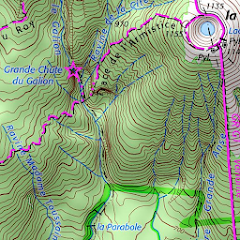
TrekMe is an Android app to get live position on a map and other useful information, without ever needing an internet connection (except when creating a map). It's ideal for trekking, biking, or any outdoor activity.
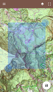
In this application, you create a map by chosing the area you want to download. Then, your map is available for offline usage (the GPS works even without mobile data).
Download from USGS, OpenStreetMap, SwissTopo, IGN (France and Spain)
Other topographic map sources will be added.
Fluid and doesn't drain the battery
Particular attention was given to efficency, low battery usage, and smooth experience.
SD card compatible
A large map can be quite heavy and may not fit into your internal memory. If you have an SD card, you can use it.
Features
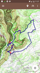
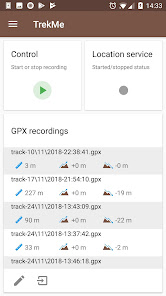
• Import, record, and share GPX files
• Marker support, with optional comments
• Real-time visualization of a GPX record, as well as its statistics (distance, elevation, ..)
• Orientation, distance, and speed indicators
• Measure a distance along a track
• Be alerted when you move away from a track
For instance, all map providers are free, except for France IGN - which requires an annual subscription.
For professionals and enthousiasts
If you have an external GPS with bluetooth*, you can connect it to TrekMe and use it instead of the internal GPS of your device. This is especially useful when your activity (aeronautic, professional topography, ..) requires better precision and updating your position at a higher frequency than every second.
(*) Supports NMEA over bluetooth
Privacy
During a GPX recording, the app collects location data even when the app is closed or not in use. However, your location will never be shared with anyone and gpx files are stored locally on your device.
General TrekMe guide
https://github.com/peterLaurence/TrekMe/blob/master/Readme.md
In this application, you create a map by chosing the area you want to download. Then, your map is available for offline usage (the GPS works even without mobile data).
Download from USGS, OpenStreetMap, SwissTopo, IGN (France and Spain)
Other topographic map sources will be added.
Fluid and doesn't drain the battery
Particular attention was given to efficency, low battery usage, and smooth experience.
SD card compatible
A large map can be quite heavy and may not fit into your internal memory. If you have an SD card, you can use it.
Features
• Import, record, and share GPX files
• Marker support, with optional comments
• Real-time visualization of a GPX record, as well as its statistics (distance, elevation, ..)
• Orientation, distance, and speed indicators
• Measure a distance along a track
• Be alerted when you move away from a track
For instance, all map providers are free, except for France IGN - which requires an annual subscription.
For professionals and enthousiasts
If you have an external GPS with bluetooth*, you can connect it to TrekMe and use it instead of the internal GPS of your device. This is especially useful when your activity (aeronautic, professional topography, ..) requires better precision and updating your position at a higher frequency than every second.
(*) Supports NMEA over bluetooth
Privacy
During a GPX recording, the app collects location data even when the app is closed or not in use. However, your location will never be shared with anyone and gpx files are stored locally on your device.
General TrekMe guide
https://github.com/peterLaurence/TrekMe/blob/master/Readme.md
Updated on
Safety starts with understanding how developers collect and share your data. Data privacy and security practices may vary based on your use, region, and age. The developer provided this information and may update it over time.

No data shared with third parties
Learn more about how developers declare sharing

No data collected
Learn more about how developers declare collection
Ratings and reviews
3.9
594 reviews

Joshua Gottdenker
- Flag inappropriate
March 25, 2024
Very clean modern design. Good prices for extra features. Honest. Wish I could add custom layers and record tracks to external PostGIS dB... That would be epic.
33 people found this review helpful

Chris K
- Flag inappropriate
January 21, 2024
Does EXACTLY what I want in an app like this. Great offline maps. I use the OSM and USGS topo maps. Tracks accurately and it a relatively simple UI. Darn near perfect.
64 people found this review helpful
Pierre Laurence
January 29, 2024
Thanks!

Jim bell
- Flag inappropriate
April 18, 2024
This app uses strange terminology, and it is weird and confusing. It needs a lot of work.
3 people found this review helpful
What's new
4.0.7, .., 4.0.0
• Refreshed design
• Minor fixes
• New: change color of markers
• Maps created from this release can now be repaired by downloading missing tiles (if any), or updated by re-downloading all the content.
This can be done from the settings of a map.
3.8.1, 3.8.0
• Fix various accessibility issues
• Redesign of the trail search feature
• Fixed issue which could cause a track to be overwritten by a newly imported track


