CPW Mobile PDF
1K+
Downloads

Everyone
info

About this app
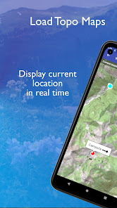
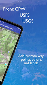
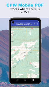
The Colorado Parks and Wildlife Mobile PDF app pinpoints your location on a map without the need for an internet or cell tower connection. Even in battery-saving airplane mode, CPW Mobile PDF makes use of your phone's E911 capability to display your location in real-time on downloaded georeferenced PDF maps. Get PDF maps from CPW online Map Library, personalize maps using the Colorado Hunting and Fishing Atlas, USFS, USGS, or your favorite site. Customized waypoints can be added and saved with each map. Build a mobile map library that can be sorted by proximity to each map and more. Go mobile! Whether you are hiking, hunting, or fishing this app will be your guide in the backcountry.
CPW Mobile PDF Features:
• Download topo or aerial photo maps from the CPW online Map Library, CPW HuntingAtlas, CPW FishingAtlas, USFS, USGS, or other sites.
• Display current location and direction in real-time.
• Zoom in on the details of your map.
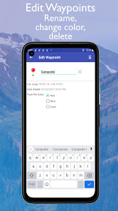
• Add waypoints in three different colors.
• Customize your waypoint labels.
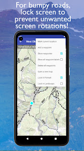
• Display waypoint latitude, longitude, and creation date.
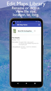
• Build a PDF maps library with custom map names.
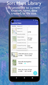
• Display real-time proximity to each PDF map.
• Sort PDF maps by: proximity, name, file size, or date added.
• Lock map in portrait or landscape mode so bumpy roads do not cause unwanted screen rotations!
CPW Mobile PDF Features:
• Download topo or aerial photo maps from the CPW online Map Library, CPW HuntingAtlas, CPW FishingAtlas, USFS, USGS, or other sites.
• Display current location and direction in real-time.
• Zoom in on the details of your map.
• Add waypoints in three different colors.
• Customize your waypoint labels.
• Display waypoint latitude, longitude, and creation date.
• Build a PDF maps library with custom map names.
• Display real-time proximity to each PDF map.
• Sort PDF maps by: proximity, name, file size, or date added.
• Lock map in portrait or landscape mode so bumpy roads do not cause unwanted screen rotations!
Updated on
Safety starts with understanding how developers collect and share your data. Data privacy and security practices may vary based on your use, region, and age. The developer provided this information and may update it over time.

No data shared with third parties
Learn more about how developers declare sharing

No data collected
Learn more about how developers declare collection
What's new
- Save user preferences for: showing waypoints, labels, adjacent maps, locking orientation.
- Load adjacent maps quickly while viewing a map.
- Easily edit, delete, or move waypoints.
- Add a waypoint by entering a lat/long.
- Dark mode icons.
- Performance increase.
- Improve accessibility for variable text size.
- Updated help documentation.
- Update current location more often.
- More error checking.


