HeliPlates
100+
Downloads

Everyone
info

About this app
Caltrans has developed informational dataplates, or "HeliPlates," that provide permitted approach paths and other information for all the permitted Hospital Heliports in California. We hope this information will be helpful to emergency planners, helicopter operators, and other users.
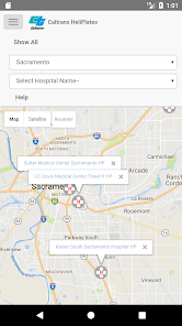
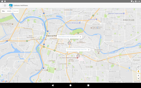
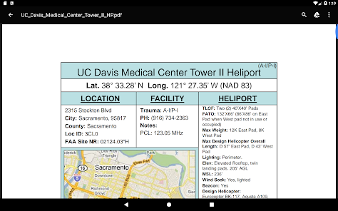
The Caltrans HeliPlates app displays a map of Hospital Heliports in California that you can view by Geographic Region or County. You can select a HeliPlate for a specific Hospital Heliport using either the interactive map or by directly choosing the Hospital Name. The HeliPlates include:
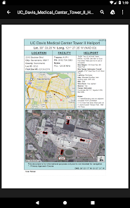
- Hospital Name
- Hospital Heliport Geographic “Nav” Coordinates
- Heliport Info and Dimensions
- Hospital Facility and FAA Information
- Regional Map showing the location of the heliport
- Aerial Photo showing the heliport and Permitted Approach Paths
Additionally, HeliPlates can be saved for offline use.
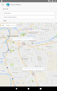
The Caltrans HeliPlates app displays a map of Hospital Heliports in California that you can view by Geographic Region or County. You can select a HeliPlate for a specific Hospital Heliport using either the interactive map or by directly choosing the Hospital Name. The HeliPlates include:
- Hospital Name
- Hospital Heliport Geographic “Nav” Coordinates
- Heliport Info and Dimensions
- Hospital Facility and FAA Information
- Regional Map showing the location of the heliport
- Aerial Photo showing the heliport and Permitted Approach Paths
Additionally, HeliPlates can be saved for offline use.
Updated on
Safety starts with understanding how developers collect and share your data. Data privacy and security practices may vary based on your use, region, and age. The developer provided this information and may update it over time.

No data shared with third parties
Learn more about how developers declare sharing

No data collected
Learn more about how developers declare collection
What's new
Maintenance update.