Work Map
Contains ads
500+
Downloads

Everyone
info


About this app
Are you still using outdated handheld RTK devices for your surveying work?
Are you still frustrated by not being able to instantly know the location and progress of your team members?
Are you troubled by the inability to overlay CAD files on maps while working outdoors?
Are you looking for software that can view and manage markers and plan routes?
With the Work Map, everything becomes possible.
This is a software developed for professionals in various industries such as agriculture, telecommunications, construction, power, forestry, water resources, real estate, delivery personnel, as well as outdoor enthusiasts such as hikers, mountain bikers, climbers, trail runners, and treasure hunters.
Whether you are a farmer needing to manage gardens, farmland, and pastures, an engineer or construction worker needing to view CAD/KML/GPX files, or personnel in fields like forestry, power, water resources, and telecommunications needing to annotate on maps, or even a traveler or delivery person needing to mark locations, record tracks, and plan routes, our product XX will be your perfect solution. It is an easy-to-use and powerful offline outdoor map measurement and annotation tool.
The current features include:
Integration of Google Satellite Map, Google Hybrid Map, ArcGIS Satellite Map, Mapbox Satellite Map, and historical imagery to help visualize the past state of the land.
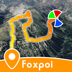
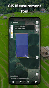
Manual measurement functionality allows you to measure distances and land areas by drawing points on the map, supporting easy switching between length and area units. There is also a wide selection of annotation icons available.
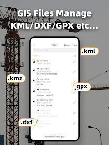
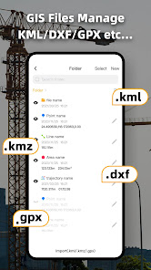
Folder management feature for easy and efficient file management. You can import and manage KML/KMZ/GPX files and view them on the map.
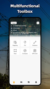
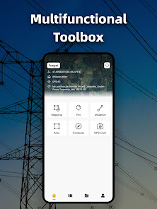
A rich toolbox including a compass/level function, ensuring you don't lose your way when using it outdoors; a watermark camera feature, instantly adding time, latitude, longitude, altitude, and location information to photos; track recording functionality, so you don't have to worry about getting lost during your travels or field surveys.
Features currently under development include:
Team management and real-time location sharing of team members.
Route optimization to plan the most efficient routes, eliminating unnecessary detours.
CAD file import functionality, allowing DXF files to be overlaid and viewed on the map.
Offline map functionality, enabling the pre-download of satellite maps for use even without an internet connection.
GPS measurement functionality, allowing precise measurement of area and distance by walking around the land.
Foxpoi Team
Are you still frustrated by not being able to instantly know the location and progress of your team members?
Are you troubled by the inability to overlay CAD files on maps while working outdoors?
Are you looking for software that can view and manage markers and plan routes?
With the Work Map, everything becomes possible.
This is a software developed for professionals in various industries such as agriculture, telecommunications, construction, power, forestry, water resources, real estate, delivery personnel, as well as outdoor enthusiasts such as hikers, mountain bikers, climbers, trail runners, and treasure hunters.
Whether you are a farmer needing to manage gardens, farmland, and pastures, an engineer or construction worker needing to view CAD/KML/GPX files, or personnel in fields like forestry, power, water resources, and telecommunications needing to annotate on maps, or even a traveler or delivery person needing to mark locations, record tracks, and plan routes, our product XX will be your perfect solution. It is an easy-to-use and powerful offline outdoor map measurement and annotation tool.
The current features include:
Integration of Google Satellite Map, Google Hybrid Map, ArcGIS Satellite Map, Mapbox Satellite Map, and historical imagery to help visualize the past state of the land.
Manual measurement functionality allows you to measure distances and land areas by drawing points on the map, supporting easy switching between length and area units. There is also a wide selection of annotation icons available.
Folder management feature for easy and efficient file management. You can import and manage KML/KMZ/GPX files and view them on the map.
A rich toolbox including a compass/level function, ensuring you don't lose your way when using it outdoors; a watermark camera feature, instantly adding time, latitude, longitude, altitude, and location information to photos; track recording functionality, so you don't have to worry about getting lost during your travels or field surveys.
Features currently under development include:
Team management and real-time location sharing of team members.
Route optimization to plan the most efficient routes, eliminating unnecessary detours.
CAD file import functionality, allowing DXF files to be overlaid and viewed on the map.
Offline map functionality, enabling the pre-download of satellite maps for use even without an internet connection.
GPS measurement functionality, allowing precise measurement of area and distance by walking around the land.
Foxpoi Team
Updated on
Safety starts with understanding how developers collect and share your data. Data privacy and security practices may vary based on your use, region, and age. The developer provided this information and may update it over time.


What's new
fix some bugs


