
ShipIntel by Maritime Optima
1K+
Downloads

Everyone
info
About this app
ShipIntel - Better decisions today with tomorrow's maritime solution!
ShipIntel is for any maritime company focusing on team efficiency and maximizing profit.
A perfect complementary team software to your existing solutions where you can tailor-make your software by selecting the modules you want.
Whether you are a broker, a chartering manager, or working for some other company involved with the maritime industry, you should run your organization more efficiently. We aim to make internal communication and data exchange between partners more efficient so you can get more work done, whether working for a large enterprise or a small business.
ShipIntel is available cross-platform. Log in to ShipIntel from your mobile or web. Your data and work are always in sync across platforms.
Why give ShipIntel a try?
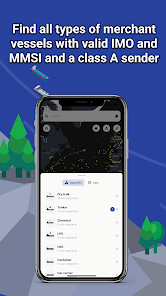
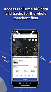
LIVE AIS Data
Find where all types of vessels are in almost real-time; AIS positions, the vessels' last port of call, and the next port they are heading to, with ETA, present speed, and estimated laden/ballast condition. All the vessels have a valid IMO, MMSI, and use a class A AIS sender. The vessels are divided into types/and sizes (segments & sub-segments).
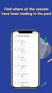
Historical AIS data
Find where all the vessels have been trading in the past.
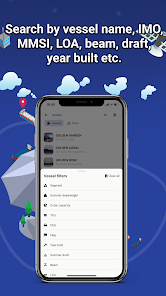
Search for vessels and ports
Search and find vessels by name, IMO, MMSI, or expand your search using LOA, beam, draft, year built, etc. Search and find ports by name, country, and cargo type.
Vessel and port lists
Create unlimited numbers of fleet lists or lists of ports, and add them as layers to your map.
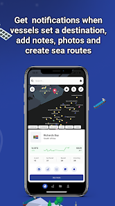
Be notified
Be notified when vessels set a destination, arrive in a port or at anchorages, pass a line, or arrive or depart from a region.
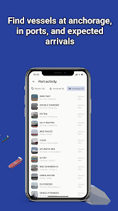
You will also find vessels in ports, recent departed, and waiting at anchorages listed with name, segment, and arrival time. You will find tides, bunker grades, prices, and availability in each port. Vessels presently in ports, at anchor, and vessels just departed.
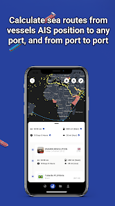
A sea route (distance) calculator
Create sea route from any vessel's present AIS position to any port or multiple ports. Get the bunker consumption and distance in nautical miles from the vessel's AIS position to any port or a combination of ports. Find the ETA, days at sea, bunker ports along the route, and estimated bunker consumption. You can also route between ports.
Add notes, photos, and documents directly attached to a vessel or port or a list of vessels or ports.
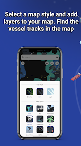
Map information layers
- Sea Ice, Piracy, and Marine weather are updated every 24 hours.
- War zones, ECA/SECA, Economical Zone, Load Lines, INL and Polar Codes and wind farms.
- Click on the layers for information on constraints.
- Choose between map styles and satellite.
A cross-platform software. Always in sync so you always have the latest update in your pocket.
A dedicated and free support chat operated by people with shipping experience is integrated to assist you anytime.
Please stop by and learn more on our web page: https://maritimeoptima.com/shipintel
ShipIntel is for any maritime company focusing on team efficiency and maximizing profit.
A perfect complementary team software to your existing solutions where you can tailor-make your software by selecting the modules you want.
Whether you are a broker, a chartering manager, or working for some other company involved with the maritime industry, you should run your organization more efficiently. We aim to make internal communication and data exchange between partners more efficient so you can get more work done, whether working for a large enterprise or a small business.
ShipIntel is available cross-platform. Log in to ShipIntel from your mobile or web. Your data and work are always in sync across platforms.
Why give ShipIntel a try?
LIVE AIS Data
Find where all types of vessels are in almost real-time; AIS positions, the vessels' last port of call, and the next port they are heading to, with ETA, present speed, and estimated laden/ballast condition. All the vessels have a valid IMO, MMSI, and use a class A AIS sender. The vessels are divided into types/and sizes (segments & sub-segments).
Historical AIS data
Find where all the vessels have been trading in the past.
Search for vessels and ports
Search and find vessels by name, IMO, MMSI, or expand your search using LOA, beam, draft, year built, etc. Search and find ports by name, country, and cargo type.
Vessel and port lists
Create unlimited numbers of fleet lists or lists of ports, and add them as layers to your map.
Be notified
Be notified when vessels set a destination, arrive in a port or at anchorages, pass a line, or arrive or depart from a region.
You will also find vessels in ports, recent departed, and waiting at anchorages listed with name, segment, and arrival time. You will find tides, bunker grades, prices, and availability in each port. Vessels presently in ports, at anchor, and vessels just departed.
A sea route (distance) calculator
Create sea route from any vessel's present AIS position to any port or multiple ports. Get the bunker consumption and distance in nautical miles from the vessel's AIS position to any port or a combination of ports. Find the ETA, days at sea, bunker ports along the route, and estimated bunker consumption. You can also route between ports.
Add notes, photos, and documents directly attached to a vessel or port or a list of vessels or ports.
Map information layers
- Sea Ice, Piracy, and Marine weather are updated every 24 hours.
- War zones, ECA/SECA, Economical Zone, Load Lines, INL and Polar Codes and wind farms.
- Click on the layers for information on constraints.
- Choose between map styles and satellite.
A cross-platform software. Always in sync so you always have the latest update in your pocket.
A dedicated and free support chat operated by people with shipping experience is integrated to assist you anytime.
Please stop by and learn more on our web page: https://maritimeoptima.com/shipintel
Updated on
Safety starts with understanding how developers collect and share your data. Data privacy and security practices may vary based on your use, region, and age. The developer provided this information and may update it over time.


What's new
Improved features and bug fixes.


