mKart Marine Navigation
In-app purchases
3.5star
121 reviews
10K+
Downloads

Everyone
info


About this app
mKart is easy to install and use online marine navigation software (from creators of ECS/ECDIS dKart Navigator) with the fastest chart engine using hybrid ON/OFF sea maps concept and 3D nautical charts.
Product Highlights:
WEB CONSOLE:
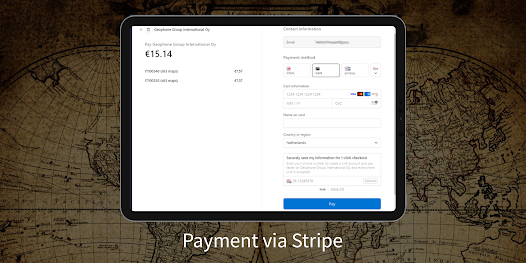
E-shop;
ENCs and cartographic products Catalogue;
Portfolio optimization;
Fleet management;
Roots and tracks;
Data exchange;
Accounting;
SAFETY IS IN FOCUS:
Automatic routing and NO-GO Area display;
Dangerous depths and objects automatic control.
Safe sailing alternative and recommendations;
Meeting points and hazardous traverses calculations.
Background monitoring: dangers’ and ships’ alerts, all along the route.
Apple watch support.
DOCKING:
Click on the chart, select the location and follow the docking path.
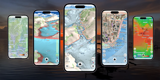
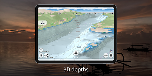
3D MARINE AND OSM CHARTS:
3D marine and OSM charts are uploaded and displayed automatically. 3D sea floor, land’s relief, 3D buildings, ships and infrastructure models contribute to better seafarers orientation and awareness.
FREE NOAA ENCs:
Online NOAA nautical charts are being installed automatically via Internet by customer’s position or while browsing and stored for off-line use. Updating is performed in the same way.
SMART PANELS:
Swipe from below and from side to side. Profiles of seabed relief, safety path simulator, docking.
MARINE ROUTE PLANNER:
Save time with integrated sea and river auto routes functionality. Safety checks is implemented along with route monitoring functionality and warning system.
NO GO ZONE:
Display safety area is filled up graphically on the sea map by only safe depth. Safety zone is calculated trough 3D sea bottom model.
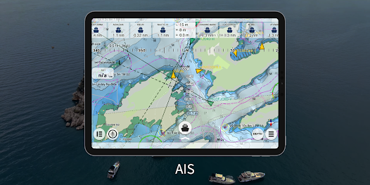
MARINE TRAFFIC:
Marine traffic data can be obtained from open AIS streams over Internet to display and identify dangerous targets.
COMPASS MODE:
Get a quick look around while boat navigation with advanced VR option for better orientation and using visual aids for navigation effectively.
SEARCH:
Search all objects and information on ENC S-57 charts trough SW and data via universal search function.
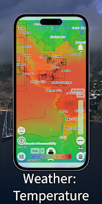
MARINE WEATHER:
mKart online services allows to deliver highly detailed weather information and forecast.
TRACKS AND WAYPOINTS:
PLT and WPT import and export, recording and displaying on the chart.
Product Highlights:
WEB CONSOLE:
E-shop;
ENCs and cartographic products Catalogue;
Portfolio optimization;
Fleet management;
Roots and tracks;
Data exchange;
Accounting;
SAFETY IS IN FOCUS:
Automatic routing and NO-GO Area display;
Dangerous depths and objects automatic control.
Safe sailing alternative and recommendations;
Meeting points and hazardous traverses calculations.
Background monitoring: dangers’ and ships’ alerts, all along the route.
Apple watch support.
DOCKING:
Click on the chart, select the location and follow the docking path.
3D MARINE AND OSM CHARTS:
3D marine and OSM charts are uploaded and displayed automatically. 3D sea floor, land’s relief, 3D buildings, ships and infrastructure models contribute to better seafarers orientation and awareness.
FREE NOAA ENCs:
Online NOAA nautical charts are being installed automatically via Internet by customer’s position or while browsing and stored for off-line use. Updating is performed in the same way.
SMART PANELS:
Swipe from below and from side to side. Profiles of seabed relief, safety path simulator, docking.
MARINE ROUTE PLANNER:
Save time with integrated sea and river auto routes functionality. Safety checks is implemented along with route monitoring functionality and warning system.
NO GO ZONE:
Display safety area is filled up graphically on the sea map by only safe depth. Safety zone is calculated trough 3D sea bottom model.
MARINE TRAFFIC:
Marine traffic data can be obtained from open AIS streams over Internet to display and identify dangerous targets.
COMPASS MODE:
Get a quick look around while boat navigation with advanced VR option for better orientation and using visual aids for navigation effectively.
SEARCH:
Search all objects and information on ENC S-57 charts trough SW and data via universal search function.
MARINE WEATHER:
mKart online services allows to deliver highly detailed weather information and forecast.
TRACKS AND WAYPOINTS:
PLT and WPT import and export, recording and displaying on the chart.
Updated on
Safety starts with understanding how developers collect and share your data. Data privacy and security practices may vary based on your use, region, and age. The developer provided this information and may update it over time.

No data shared with third parties
Learn more about how developers declare sharing

This app may collect these data types
Location, Personal info and 2 others

Data isn’t encrypted

You can request that data be deleted
Ratings and reviews
3.4
114 reviews

pax lacson
- Flag inappropriate
October 12, 2022
on trial mode, meantime the display is par and i rate 3 star. trying to figure out how to download enc charts
2 people found this review helpful

Henry Rhyne
- Flag inappropriate
September 1, 2022
Sucks, can't even register. Never receive password by email. Help screen no help. Help takes you some irrelevant screen. Unusable.
3 people found this review helpful

paul s
- Flag inappropriate
October 12, 2021
Crashes on android and pc can't register. Wont do anything.
4 people found this review helpful
What's new
We have added the ability to purchase an ENC via the GetENC service to the app. Now buying a PRIMAR charts has become even faster and easier.


