Black Hills NF Map Navigator
10+
Downloads

Everyone
info

About this app
Flytomap is a valid and interesting alternative,
Featured on the Deck
Featured on Geomedia
Try now the new FlyToMap web viewer to see all available maps worldwide !!! Visit viewer.flytomap.com
“Download any FlytoMap application for Free! By purchasing FlytoMap All-in-One App.”
!! Watch "Flytomap GPS" app video on www.appreview.com and www.youtube.com !!
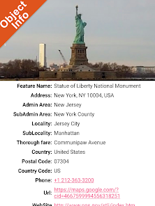
FlytoMap provides complete, quick and easy to use map applications for navigation for your phone and Tablet. Continues in the tradition of offering depth of information and functionality across expected places all over the world, exploring the map you get maximum details obtaining detailed information of each object on the map.
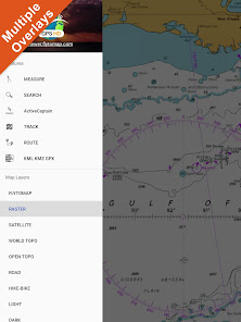
Worldwide Marine and Outdoor Maps available when connected, thanks to viewer.flytomap.com
Worldwide Satellite images overlay on charts
Worldwide Terrain features overlay on charts, thanks to Open Street Map, Open Cycle Map, Earth,topo maps by ESRI
“Park Map contains Guide for quick reference with necessary links”
Use to Explore:
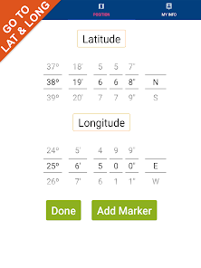
√ Latitudes and Longitudes to go to your favorite places
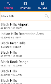
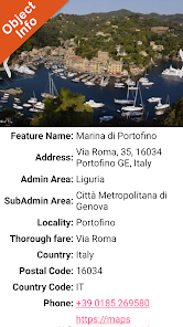
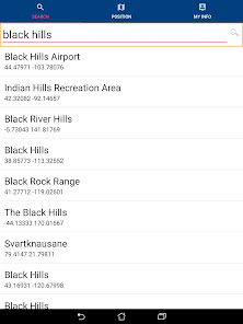
√ Search your Favorite points directly
√ Zoom, Rotate and Pan fast just by a finger touch
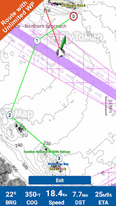
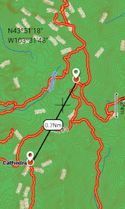
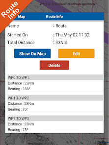
√ Route with unlimited waypoints
√ With Head Up and Course Up feature
√ Geocompass
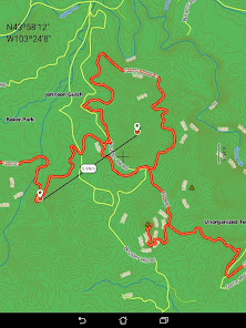
√ Contains Park Map Guide
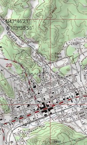
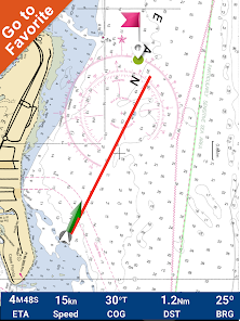
√ Navigate and see your GPS position on the map
√ Heading Vector Towards the direction movement
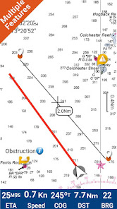
√ Distance Measurement Tool to easily calculate the distance from one location to another
√ Insert the target/destination and see in real time your speed, distance and bearing
√ background mode - Flytomap works in background as well, you can swap with another app and receive/make calls send sms while panning and zooming.
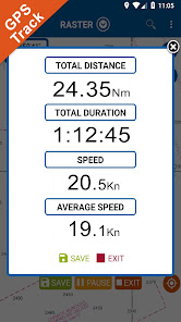
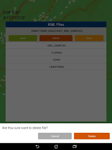
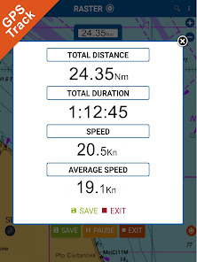
√ Unlimited Tracks share via email, visible on Google, Flytomap Viewer, KMZ format - Store your track without the need of cellular data or mobile signal
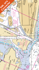
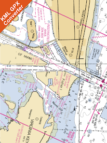
√ KMZ KML from / to GPX Converter
√ Optimized battery usage
√ And so much more to come - It’s the only app you will ever need! Our charts are installed on: NAVICO LOWRANCE B&G NORTHSTAR EAGLE SIMRAD
Follow us:
▶Twitter @flytomap
▶Web Site flytomap.com
▶Web App viewer.flytomap.com
▶Facebook facebook.com/flytomap
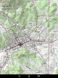
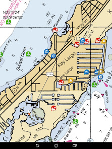
The cartography of Black Hills National Forest is included in this application
Flytomap is committed to constant improvement, this App is developed with the help of professional boaters to get the best experience on the sea, we listen to our users and systematically add the most requested features.
Thank you for the feedback!
Additional info about Flytomap products
PARK MAPS:
Park map applications are extremely advanced contains embedded electronic charts with all information collected from the National Park Service and local sources. The maps contain all multiple trails (Hiking, biking, Stairway trails, Bicycle trails, Equestrian trails etc.,) and Point of interests (POI) like Campgrounds, Eating places, Ranger Stations, Picnic areas, Boat/Canoe launching, Parking areas etc., which are provided depending on the relevant park areas they exists.
“Covers all Trails, Lakes and Rivers within the Parks”
“Covers complete park boundary from (NPS)”
“Elevation Contours with 10 meters interval”
“Mountain Summits”
“All Roads and Railways from TIGER”
LAKE MAPS:
We offer high quality lake maps with detailed information and important features compressed to assure the larger coverage in USA region. Lake maps contain most important DNR lakes with detailed ‘Depth Contours, Boat Ramps, Fishing spots etc. Also includes Trails, Roads and Railways information.
“We work to delight your moments”
! Enjoy great Journeys!
Featured on the Deck
Featured on Geomedia
Try now the new FlyToMap web viewer to see all available maps worldwide !!! Visit viewer.flytomap.com
“Download any FlytoMap application for Free! By purchasing FlytoMap All-in-One App.”
!! Watch "Flytomap GPS" app video on www.appreview.com and www.youtube.com !!
FlytoMap provides complete, quick and easy to use map applications for navigation for your phone and Tablet. Continues in the tradition of offering depth of information and functionality across expected places all over the world, exploring the map you get maximum details obtaining detailed information of each object on the map.
Worldwide Marine and Outdoor Maps available when connected, thanks to viewer.flytomap.com
Worldwide Satellite images overlay on charts
Worldwide Terrain features overlay on charts, thanks to Open Street Map, Open Cycle Map, Earth,topo maps by ESRI
“Park Map contains Guide for quick reference with necessary links”
Use to Explore:
√ Latitudes and Longitudes to go to your favorite places
√ Search your Favorite points directly
√ Zoom, Rotate and Pan fast just by a finger touch
√ Route with unlimited waypoints
√ With Head Up and Course Up feature
√ Geocompass
√ Contains Park Map Guide
√ Navigate and see your GPS position on the map
√ Heading Vector Towards the direction movement
√ Distance Measurement Tool to easily calculate the distance from one location to another
√ Insert the target/destination and see in real time your speed, distance and bearing
√ background mode - Flytomap works in background as well, you can swap with another app and receive/make calls send sms while panning and zooming.
√ Unlimited Tracks share via email, visible on Google, Flytomap Viewer, KMZ format - Store your track without the need of cellular data or mobile signal
√ KMZ KML from / to GPX Converter
√ Optimized battery usage
√ And so much more to come - It’s the only app you will ever need! Our charts are installed on: NAVICO LOWRANCE B&G NORTHSTAR EAGLE SIMRAD
Follow us:
▶Twitter @flytomap
▶Web Site flytomap.com
▶Web App viewer.flytomap.com
▶Facebook facebook.com/flytomap
The cartography of Black Hills National Forest is included in this application
Flytomap is committed to constant improvement, this App is developed with the help of professional boaters to get the best experience on the sea, we listen to our users and systematically add the most requested features.
Thank you for the feedback!
Additional info about Flytomap products
PARK MAPS:
Park map applications are extremely advanced contains embedded electronic charts with all information collected from the National Park Service and local sources. The maps contain all multiple trails (Hiking, biking, Stairway trails, Bicycle trails, Equestrian trails etc.,) and Point of interests (POI) like Campgrounds, Eating places, Ranger Stations, Picnic areas, Boat/Canoe launching, Parking areas etc., which are provided depending on the relevant park areas they exists.
“Covers all Trails, Lakes and Rivers within the Parks”
“Covers complete park boundary from (NPS)”
“Elevation Contours with 10 meters interval”
“Mountain Summits”
“All Roads and Railways from TIGER”
LAKE MAPS:
We offer high quality lake maps with detailed information and important features compressed to assure the larger coverage in USA region. Lake maps contain most important DNR lakes with detailed ‘Depth Contours, Boat Ramps, Fishing spots etc. Also includes Trails, Roads and Railways information.
“We work to delight your moments”
! Enjoy great Journeys!
Updated on
Safety starts with understanding how developers collect and share your data. Data privacy and security practices may vary based on your use, region, and age. The developer provided this information and may update it over time.

No data shared with third parties
Learn more about how developers declare sharing

No data collected
Learn more about how developers declare collection
What's new
Updated to latest Android version.


