

DroidEFB, US Only
In-app purchases

4.4star
605 reviews
100K+
Downloads

Everyone
info


About this app
DroidEFB (single word, droid.e.f.b) is, you guessed it, an Electronic Flight Bag for Android! Developed by pilots and enhanced via user feedback, this flight planning app is designed to be simple and intuitive while featuring a suite of essential tools including aviation GPS with moving map. DroidEFB is like ForeFlight for Android! Full featured and reliable, DroidEFB is a must-have aviation app for general aviation and professional pilots using :
FAA Approved - Class 1 Electronic Flight Bag (EFB) - Reference AC91-78 and AIM Chapter 1
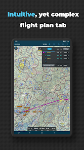
*En-route GPS navigation via moving map
*NOAA aviation weather and NEXRAD radar
*Geo-referenced approach plates and taxi diagrams
*ADS-B compatibility
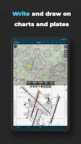
*Draw on charts and approach plates
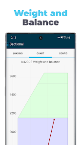
*Weight and balance
*Translated TAF and METAR
*Fuel price and FBO information
*Flight plan filing
*Points of Interest (POI) search
SUBSCRIPTION OPTIONS:
30-day free trial
$6.99 per month, VFR
$74.99 per year, VFR
$149.99 per year, VFR + IFR with Geo-referenced approach plates
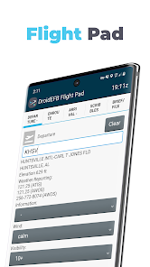
An Electronic Flight Bag (EFB) reduces cockpit workload and provides relevant information when you need it. DroidEFB overlays current position and flight plan onto an FAA Sectional, TAC, Low Altitude or High-Altitude chart. On the ground, current weather is displayed for long range planning; helping pilots visualize the impact current conditions will have on their flight.
Easily amend airports, waypoints, victor/jet airways, STARs, DPs, GPS coordinates and DME. Advanced navigation log takes into account current winds aloft for precise planning.
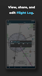
Routes flown are stored as GPS breadcrumbs and can be uploaded and viewed in Google Earth. https://droidefb.com/tutorials/
Charts and plates are viewable via our servers with an Internet connection and are downloadable for offline use. RouteMinder™ automatically checks the planned route for Charts needing downloaded.
DroidEFB can be used to receive and file official briefings! Register at www.1800wxbrief.com/Website/ and enable Avilution/DroidEFB in the list of service providers (Flight Planning & Briefing > Service Provider) to receive notifications.
DroidEFB Features:
-Point of Interest (POI) Search - find and save airports, street addresses, business names, coordinates
-Approach plates and airport diagrams (Geo-referenced with Premium subscription)
-Create, save, and sync user waypoints and Flight Plans
-NEXRAD and ADS-B traffic (TIS-B) w/supported devices
-Write or draw on charts and terminal procedures
-Arrival (STAR) and Departure (DP) procedures
-Sophisticated weight and balance
-FBO Fuel Price (100LL; Jet A)
-VSR (vertical speed required)
-Special Use Airspace (SUA)
-Store data on External SD
-A/FD (chart supplement)
-Pinch zoom and measure
-Redundant data servers
-Real-time GPS tracking
-Grand Canyon Charts
-Helicopter Charts
-Track prediction
-QuickWeather (free)
-Auto Logbook
-SAR patterns
-Track Log
Weather Overlay:
-NEXRAD (Internet, MobileLink, ADS-B)
-SIGMET / AIRMET (Internet, MobileLink)
-METAR (Internet, MobileLink, ADS-B)
-PIREP (Internet, MobileLink, ADS-B)
-TAF (Internet, MobileLink, ADS-B)
-Surface and winds aloft (Internet)
-Current Icing Potential (Internet)
-Satellite imagery (MobileLink)
-Lightning strikes (MobileLink)
-Freezing levels (MobileLink)
-NOTAMs (Internet, ADS-B)
-Area forecast (Internet)
-TFRs (Internet)
Third party devices and program support:
-Baron MobileLink
-iLevil with AHRS
-Microsoft FSX
-Dual XGPS
-ZAON XRX
-Pathfinder
-SkyRadar
-X-Plane
-Stratux
-Dynon
For pilots using phones and tablets running Android 5.1 or higher.
One subscription or free trial may be used on multiple devices such as a phone and tablet. Subscriptions authenticated using the Google account on your Android device. Password and Credit Card information are never shared with DroidEFB.
Rooted devices not "officially" supported.
We cannot respond to feedback or app issues left in Google Play reviews. For support, visit https://www.droidefb.com
FAA Approved - Class 1 Electronic Flight Bag (EFB) - Reference AC91-78 and AIM Chapter 1
*En-route GPS navigation via moving map
*NOAA aviation weather and NEXRAD radar
*Geo-referenced approach plates and taxi diagrams
*ADS-B compatibility
*Draw on charts and approach plates
*Weight and balance
*Translated TAF and METAR
*Fuel price and FBO information
*Flight plan filing
*Points of Interest (POI) search
SUBSCRIPTION OPTIONS:
30-day free trial
$6.99 per month, VFR
$74.99 per year, VFR
$149.99 per year, VFR + IFR with Geo-referenced approach plates
An Electronic Flight Bag (EFB) reduces cockpit workload and provides relevant information when you need it. DroidEFB overlays current position and flight plan onto an FAA Sectional, TAC, Low Altitude or High-Altitude chart. On the ground, current weather is displayed for long range planning; helping pilots visualize the impact current conditions will have on their flight.
Easily amend airports, waypoints, victor/jet airways, STARs, DPs, GPS coordinates and DME. Advanced navigation log takes into account current winds aloft for precise planning.
Routes flown are stored as GPS breadcrumbs and can be uploaded and viewed in Google Earth. https://droidefb.com/tutorials/
Charts and plates are viewable via our servers with an Internet connection and are downloadable for offline use. RouteMinder™ automatically checks the planned route for Charts needing downloaded.
DroidEFB can be used to receive and file official briefings! Register at www.1800wxbrief.com/Website/ and enable Avilution/DroidEFB in the list of service providers (Flight Planning & Briefing > Service Provider) to receive notifications.
DroidEFB Features:
-Point of Interest (POI) Search - find and save airports, street addresses, business names, coordinates
-Approach plates and airport diagrams (Geo-referenced with Premium subscription)
-Create, save, and sync user waypoints and Flight Plans
-NEXRAD and ADS-B traffic (TIS-B) w/supported devices
-Write or draw on charts and terminal procedures
-Arrival (STAR) and Departure (DP) procedures
-Sophisticated weight and balance
-FBO Fuel Price (100LL; Jet A)
-VSR (vertical speed required)
-Special Use Airspace (SUA)
-Store data on External SD
-A/FD (chart supplement)
-Pinch zoom and measure
-Redundant data servers
-Real-time GPS tracking
-Grand Canyon Charts
-Helicopter Charts
-Track prediction
-QuickWeather (free)
-Auto Logbook
-SAR patterns
-Track Log
Weather Overlay:
-NEXRAD (Internet, MobileLink, ADS-B)
-SIGMET / AIRMET (Internet, MobileLink)
-METAR (Internet, MobileLink, ADS-B)
-PIREP (Internet, MobileLink, ADS-B)
-TAF (Internet, MobileLink, ADS-B)
-Surface and winds aloft (Internet)
-Current Icing Potential (Internet)
-Satellite imagery (MobileLink)
-Lightning strikes (MobileLink)
-Freezing levels (MobileLink)
-NOTAMs (Internet, ADS-B)
-Area forecast (Internet)
-TFRs (Internet)
Third party devices and program support:
-Baron MobileLink
-iLevil with AHRS
-Microsoft FSX
-Dual XGPS
-ZAON XRX
-Pathfinder
-SkyRadar
-X-Plane
-Stratux
-Dynon
For pilots using phones and tablets running Android 5.1 or higher.
One subscription or free trial may be used on multiple devices such as a phone and tablet. Subscriptions authenticated using the Google account on your Android device. Password and Credit Card information are never shared with DroidEFB.
Rooted devices not "officially" supported.
We cannot respond to feedback or app issues left in Google Play reviews. For support, visit https://www.droidefb.com
Updated on
Safety starts with understanding how developers collect and share your data. Data privacy and security practices may vary based on your use, region, and age. The developer provided this information and may update it over time.

No data shared with third parties
Learn more about how developers declare sharing

This app may collect these data types
Personal info, Financial info and 2 others

Data is encrypted in transit

Data can’t be deleted
Ratings and reviews
4.3
477 reviews

John P.
- Flag inappropriate
June 4, 2021
Overall a very good app. I use it for VFR flights. Many long cross countries. Some things I would like to see are: -Improved logbook capabilities. -Voice warning (Bluetooth) for ADSB traffic, my #1 priority. -Lat and Long points seem to suffer heavy rounding, can this be improved? -Specific to my needs- a large format continuous Time to Target count down display option. I conduct formation flyovers at sporting events, funerals, etc. Timing is often based off the National Anthem or Taps. I.E once the anthem starts I need to be overhead in 1 minute and 55 seconds. A large easy to read time display with time from present position to the next waypoint would be very useful. -Rubber banding capability I plan to keep using this app. I look forward to improvements that make it even better.
63 people found this review helpful
DroidEFB, LLC - Aviation GPS
July 7, 2021
Thank you, John! We save precise coordinates, the only rounding is in the displayed name. Instead of "rubber band", users may long press anywhere on a chart to Add, Insert or Append a waypoint. If you would email support@droidefb.com with more specifics on the features you want, we will be glad to implement them!

A Google user
- Flag inappropriate
- Show review history
March 4, 2019
Edit: Thanks for the quick reply! I had confused "Max Zero Fuel weight" with "Hull weight" as I haven't ever heard it called that before. Leaving one start off for a bit of clumsiness in the UI, but maybe I'll get used to it as I go. Otherwise it's looking like it has some potential! Original post: First thing I tried was the weight and balance screen and i was unable to get it to work. just keeps saying my gross weight is -1.
51 people found this review helpful
DroidEFB, LLC - Aviation GPS
March 4, 2019
Clay, this issue is likely caused by not having the WB upper and lower limit ranges set. See tutorial step 3: https://droidefb.com/weight-and-balance/ If this doesn't fix the issue, please let me know! Thank you, support@droidefb.com
A Google user
- Flag inappropriate
- Show review history
February 29, 2020
UPDATE 2/29/20: Returning to aviation after a 12 year hiatus, I found that this has all the stuff I used to need a flight bag full of charts and gear for. Although operation is fairly intuitive, a better tutorial laying out the finer points would have improved my learning curve. Very slow (∼3 wks) responding to my claim for an advertised discount on a subscription, and my free trial expired, but ultimately they refunded the difference. Other reviewers report better response times from Support.
45 people found this review helpful
DroidEFB, LLC - Aviation GPS
February 29, 2020
Hi William, admittedly our response to your email was delayed and we apologize. We have applied the discount as advertised and look forward to your continued feedback and support. Thank you!
What's new
2.8.4:
*Prevent login prompt if no Internet
*Prevent wrong ADSB SSID
*Enable weather imagery animations in Preferences
TIP – Track Log is automatically started and stopped based on Airborne Threshold and Landing Decision Delay setting in Preferences. Optionally, tap the Flight Timer in the Flight Plan Tab to start or stop Track Log manually.
TUTORIALS: https://droidefb.com/tutorials/
DOCUMENTATION: https://droidefb.com/documentation/
MANAGE: https://droidefb.com/manage-subscription/


