
Legal Land Map - Field Names
100+
Downloads

Everyone
info
About this app
View legal land descriptions overlaid on a satellite map!
Have a legal field name and need to find it? This is the app you need!
NOTE: Please check the list of supported states below before purchasing.
The PLSS (Public Land Survey System) is a system in which land is divided into rectangular townships and sections.
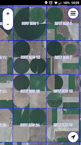
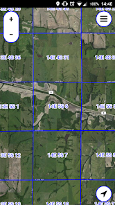
This app displays legal section names (e.g. "21W 13S 6") and borders, overlaid on a Bing satellite map.
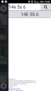
You can search for sections by their legal name.
Supported States and Provinces:
USA:
AL
AZ
AR
CA
CO
FL
ID
IL
IN
IA
KS
LA
MI
MN
MS
MO
MT
NE
NV
NM
ND
OH - Partial
OK
OR
SD
UT
WA
WI
WY
Canada:
AB
BC (Not Searchable)
MB
ON (Not Searchable)
SK
Have a legal field name and need to find it? This is the app you need!
NOTE: Please check the list of supported states below before purchasing.
The PLSS (Public Land Survey System) is a system in which land is divided into rectangular townships and sections.
This app displays legal section names (e.g. "21W 13S 6") and borders, overlaid on a Bing satellite map.
You can search for sections by their legal name.
Supported States and Provinces:
USA:
AL
AZ
AR
CA
CO
FL
ID
IL
IN
IA
KS
LA
MI
MN
MS
MO
MT
NE
NV
NM
ND
OH - Partial
OK
OR
SD
UT
WA
WI
WY
Canada:
AB
BC (Not Searchable)
MB
ON (Not Searchable)
SK
Updated on
Safety starts with understanding how developers collect and share your data. Data privacy and security practices may vary based on your use, region, and age. The developer provided this information and may update it over time.

No data shared with third parties
Learn more about how developers declare sharing

No data collected
Learn more about how developers declare collection
What's new
Add Themed Icon
Support Android 13
Support Android 13


