Norway Topo Maps
Contains adsIn-app purchases
4.2star
567 reviews
50K+
Downloads

Everyone
info

About this app
+++ NEW ! Introductory Price ! Get the full features for a small one time fee +++
Easy to use Outdoor/Offline GPS navigation app with access to the best topographic maps and satellite images for Norway.
++ For offline use PRO features needed ! ++
Turn your Andoid Phone/Tablet into an outdoor GPS for trips into the backcountry WITHOUT CELL COVERAGE. See your position on different maps, record your track or share your location with others.
Included FREE Base Map Layers:
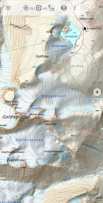
• Topographic Map 1:50.000 for complete Scandinavia ( Denmark, Norway, Sweden und Finland) with hillshading.
• Norway Base Map: Best available and up to date official maps from Kartverket.no (colored and greyscale as basemap for overlays)
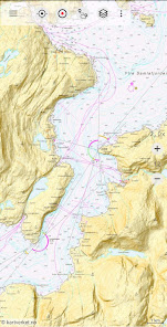
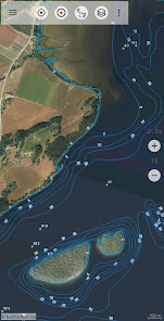
• Norway official RNC Nautical Charts
• Norway Seefloor Terrain Map
• Norway Historical Maps
• OpenStreetMaps : These crowdsourced maps are a very useful addition to other map layers. Contains many unique features.
• OpenCycleMaps: These maps are ideal to plan bicycle trips (PRO Users only !)
• ESRI Topographic
• ESRI Aerial Images
• ESRI Street Map
• Google Road Map (online access only)
• Google Satellite Images (online access only)
• Google Terrain Map (online access only)
• Bing Road Map (online access only)
• Bing Satellite Images (online access only)
• Earth At Night
Overlay Map Layers:
• Trekking-, Bycycle and Cross-Country-Ski Routes
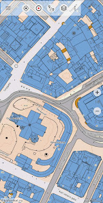
• Cadastre Map with building footprints
• Lake Depths
• River network
• Hillshading
Main features for outdoor-navigation:
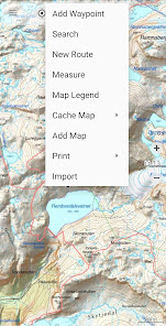
• Create and edit Waypoints
• GoTo-Waypoint-Navigation
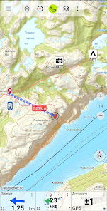
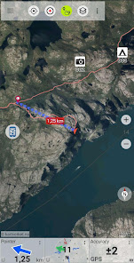
• Track Recording (with speed, elevation and accuracy profile)
• Tripmaster with fields for odometer, average speed, bearing, elevation, etc.
• GPX/KML/KMZ Export
• Search (placenames, POIs, streets)
• Customizable datafields in Map View and Tripmaster (e.g. Speed, Distance, Compass, ...)
• Share Waypoints, Tracks or Routes (via eMail, Whatsapp, Dropbox, Facebook, ..)
• Display coordinates in Lat/Lon, UTM or MGRS/USNG (Military Grid/ US National Grid)
• Record & share tracks with statistics & elevation profile
• Rotate map (Track Up & North Up)
• Get Elevation and Distance by long click on map
• Track Replay
• Add custom map tile servers
• and many more ...
Available Pro features: (Pro features available via In App Purchase)
• Offline Use - no cell coverage needed. No Roaming fees !
• Easy+Fast Bulk-download of map tiles for OFFLINE USAGE (not for Google and Bing maps)
• Create and edit Routes
• Route-Navigation (Point-to-Point Navigation)
• GPX/KML/KMZ Import/Export
• unlimited Waypoints & Tracks
• Add other Map Tile-Server
• No Ads
Offline Use:
All viewed map tiles are kept in cache. To cache large areas you need to purchase Pro features.
Use this navigation app for outdoor activities like hiking, biking, camping, climbing, riding, skiing, canoeing, hunting, offroad 4WD tours or search&rescue (SAR).
Add custom waypoints in longitude/latitude, UTM or MGRS/USNG format with WGS84 datum.
Import/Export/Share GPS-Waypoints/Tracks/Routes in GPX or Google Earth KML/KMZ format.
Preload FREE map data for areas without cell service (Pro feature !).
Comments and feature requests to info@atlogis.com
Have a look at our other outdoor navigation apps: https://play.google.com/store/search?q=atlogis
+++ We DO NOT track any user activities or collect any user data ! +++
Easy to use Outdoor/Offline GPS navigation app with access to the best topographic maps and satellite images for Norway.
++ For offline use PRO features needed ! ++
Turn your Andoid Phone/Tablet into an outdoor GPS for trips into the backcountry WITHOUT CELL COVERAGE. See your position on different maps, record your track or share your location with others.
Included FREE Base Map Layers:
• Topographic Map 1:50.000 for complete Scandinavia ( Denmark, Norway, Sweden und Finland) with hillshading.
• Norway Base Map: Best available and up to date official maps from Kartverket.no (colored and greyscale as basemap for overlays)
• Norway official RNC Nautical Charts
• Norway Seefloor Terrain Map
• Norway Historical Maps
• OpenStreetMaps : These crowdsourced maps are a very useful addition to other map layers. Contains many unique features.
• OpenCycleMaps: These maps are ideal to plan bicycle trips (PRO Users only !)
• ESRI Topographic
• ESRI Aerial Images
• ESRI Street Map
• Google Road Map (online access only)
• Google Satellite Images (online access only)
• Google Terrain Map (online access only)
• Bing Road Map (online access only)
• Bing Satellite Images (online access only)
• Earth At Night
Overlay Map Layers:
• Trekking-, Bycycle and Cross-Country-Ski Routes
• Cadastre Map with building footprints
• Lake Depths
• River network
• Hillshading
Main features for outdoor-navigation:
• Create and edit Waypoints
• GoTo-Waypoint-Navigation
• Track Recording (with speed, elevation and accuracy profile)
• Tripmaster with fields for odometer, average speed, bearing, elevation, etc.
• GPX/KML/KMZ Export
• Search (placenames, POIs, streets)
• Customizable datafields in Map View and Tripmaster (e.g. Speed, Distance, Compass, ...)
• Share Waypoints, Tracks or Routes (via eMail, Whatsapp, Dropbox, Facebook, ..)
• Display coordinates in Lat/Lon, UTM or MGRS/USNG (Military Grid/ US National Grid)
• Record & share tracks with statistics & elevation profile
• Rotate map (Track Up & North Up)
• Get Elevation and Distance by long click on map
• Track Replay
• Add custom map tile servers
• and many more ...
Available Pro features: (Pro features available via In App Purchase)
• Offline Use - no cell coverage needed. No Roaming fees !
• Easy+Fast Bulk-download of map tiles for OFFLINE USAGE (not for Google and Bing maps)
• Create and edit Routes
• Route-Navigation (Point-to-Point Navigation)
• GPX/KML/KMZ Import/Export
• unlimited Waypoints & Tracks
• Add other Map Tile-Server
• No Ads
Offline Use:
All viewed map tiles are kept in cache. To cache large areas you need to purchase Pro features.
Use this navigation app for outdoor activities like hiking, biking, camping, climbing, riding, skiing, canoeing, hunting, offroad 4WD tours or search&rescue (SAR).
Add custom waypoints in longitude/latitude, UTM or MGRS/USNG format with WGS84 datum.
Import/Export/Share GPS-Waypoints/Tracks/Routes in GPX or Google Earth KML/KMZ format.
Preload FREE map data for areas without cell service (Pro feature !).
Comments and feature requests to info@atlogis.com
Have a look at our other outdoor navigation apps: https://play.google.com/store/search?q=atlogis
+++ We DO NOT track any user activities or collect any user data ! +++
Updated on
Safety starts with understanding how developers collect and share your data. Data privacy and security practices may vary based on your use, region, and age. The developer provided this information and may update it over time.

This app may share these data types with third parties
Personal info, App activity and 2 others

No data collected
Learn more about how developers declare collection

Data is encrypted in transit

You can request that data be deleted
Ratings and reviews
4.0
507 reviews

Alan Tilling
- Flag inappropriate
January 17, 2024
Used this app for a number of years for backcountry skiing. So easy to import tracks and put multi day itineraries in folders. Maps have great detail.
2 people found this review helpful

Linguistic Learning Study With Me
- Flag inappropriate
December 5, 2023
USERS BEWARE – Data Safety – How can this app claim to collect no data, yet list out the data this app shares with third parties? Did I just install the app, to write this, then uninstall it? Yes! For I did not find out how to report this app to Google, for false/misleading information. If the developer replies, please do also mention how this can be done (if needed in the future, with others).
4 people found this review helpful
ATLOGIS Geoinformatics GmbH & Co. KG
December 5, 2023
Dear User. The app itself does not collect user data but the admob third party library does when ads are shown in the free version. You can adjust the behavior of this third party library in the settings by going to 'Preferences' -> 'Data protecttion' -> 'Personalized Advertizing'. Kind regards, Andreas

T.H
- Flag inappropriate
January 21, 2022
Perfect map app. But would like an option to always have the map pointing north. It's to easy ta accidentally turn the map and its a little annoying
6 people found this review helpful
ATLOGIS Geoinformatics GmbH & Co. KG
January 21, 2022
Thanks for your feedback ! You can quickly rotate map to north by clicking the compass rose
What's new
・Improvements & Fixes


